
US Army Desert Storm Battle Map
In stock
- SKU
- US-DSBM


- Buy 3 for $1.95 each and save 67%
Description
Gulf War Ground Campaign
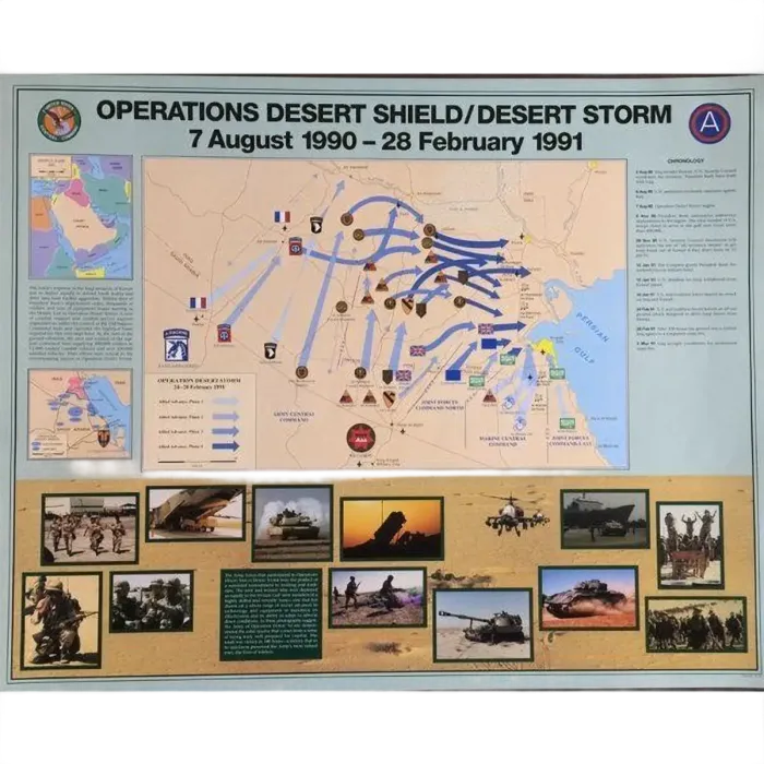
This official US Army map covers Operations Desert Shield and Desert Storm, from 7 August 1990 to 28 February 1991, on a single 30 x 24 inch sheet. The centerpiece is the 24-28 February 1991 ground offensive, drawn as color-coded arrows that follow each Coalition formation from the Saudi border into Iraq and Kuwait. It suits Gulf War veterans who want to point to where their unit went, historians and instructors who need a clear visual of the campaign, and collectors of official Army publications.
Features
- Four-Phase Allied Advance — A legend splits the ground war into four phases, and each phase gets its own shade of blue arrow so you can follow the offensive day by day.
- The Left Hook — The map shows the wide sweep west through the Iraqi desert by XVIII Airborne Corps and VII Corps, the move that outflanked Iraqi forces dug in along the Kuwaiti border.
- Unit Insignia On The Map — Shoulder patches mark individual formations, including the 82nd Airborne, 101st Airborne, 1st Cavalry, 1st Infantry and the armored divisions.
- Coalition Forces Marked — French, British, Saudi and other Coalition flags show where allied contingents fought alongside Army Central Command, Marine Central Command and Joint Forces Commands North and East.
- Kuwaiti Theater Coverage — The main map spans southern Iraq, Kuwait and northern Saudi Arabia, from As Salman and the Euphrates valley to Basra and the Persian Gulf coast.
- Inset Maps And Chronology — Two inset maps place the theater in its regional setting, and a dated chronology column runs down the right side from the August 1990 invasion to the ceasefire.
- Battlefield Photo Strip — Period photographs along the bottom show tanks, an Apache helicopter, a Patriot missile launcher, airlift and sealift, and soldiers in the field.
- CENTCOM And Third Army Emblems — The US Central Command seal and the Third Army patch flank the title at the top of the sheet.
- 30 x 24 Inch Laminated Sheet — The full sheet measures 30 by 24 inches and is laminated, so it holds up to framing, pinning to a wall or handling in a classroom.
Official Army Publication
The US Army Center of Military History, the Army's own historical office, published this map to document the Desert Shield and Desert Storm campaign. The unit placements and movement arrows reflect the Army's official record of the 1991 ground war, which makes the map a reliable teaching aid as well as a display piece. For veterans of the Gulf War, it is a printed account of the 100-hour offensive from the service that fought it.
More Information
- More From Brand
-
 Shop all US Army
Customers Also Bought


Customer Reviews
Top customer reviews
-
nice mapI was impressed by the accuracy and detail. it looks good right next to father in laws WWII map
-
Very high qualityI was pleasantly surprised that these maps were very high quality, thick, glossy poster board. Much better than i expected!