ESEE Pocket Nav Cards
Out of stock
- SKU
- ESPNC


Description
Pocket Land Nav Kit
The ESEE Pocket Nav Cards put the plotting tools and reference notes for map-and-compass navigation into a set small enough for a shirt pocket. Clear overlay cards handle grid locations, bearings and distances on a paper map. Printed cards cover land navigation procedure, and a micro waterproof notebook gives you somewhere to log coordinates in the rain. Randall's Adventure & Training and ESEE Knives designed the set for outdoorsmen, hunters and anyone working through a land navigation course.
Features
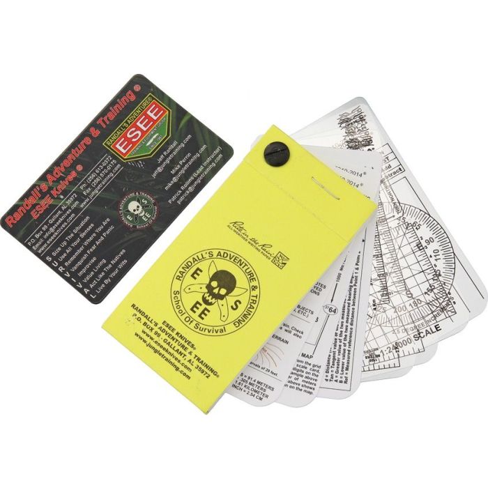
- Three Clear Overlay Cards — Transparent map scale cards with printed scales and a protractor lie flat on your map, so you can read grid locations, measure distances and take azimuths (bearings measured in degrees clockwise from north).
- Four Reference Cards — White cards printed with land navigation guidance and step-by-step instructions, useful as a field refresher or a study aid during training.
- Micro Rite In The Rain Notebook — The yellow cover holds a small pad of Rite in the Rain all-weather paper, which takes pencil or pen when wet.
- Post-Bound Fan Design — A single binding post joins the cards to the notebook, so the set fans open for use and folds back into one stack.
- GPS-To-Map Plotting — The overlays let you transfer a GPS position onto a paper map and keep navigating by map and compass if the electronics fail.
- Pocket-Size Footprint — The set measures 2.13 x 4.25 x 0.38 in (about 5.4 x 10.8 x 1 cm) and fits a shirt pocket, pack lid or admin pouch.
- Weighs About 0.1 lb — Light enough to stay in your kit permanently without you noticing it.
- SURVIVAL Acronym Card — The pictured set includes a wallet-size card printed with the SURVIVAL acronym, a short checklist of priorities for an emergency in the field.
Built For The Field
The overlays are clear plastic, so the map shows through as you plot. The information cards and notebook ride on the same binding post. Everything stays together in one stack instead of loose cards scattered through a pack. Use the set with a topographic map and a compass. It is built for traditional navigation and replaces neither.
More Information
- More From Brand